taha43
I am PLATINMODS!
Playstore Link:
ALTLAS: Trails, Maps & Hike - Apps on Google Play
Explore Trails, Record Activities, Navigate Accurately. Plan Your Adventure!
Explore, record, and share your activities, Navigate any trails and GPX files using the most accurate altimeter and tracking information with the Altimeter - Activity tracker. Find hiking trails, record your activities with the GPS, and Import/export GPX trails.
Download the ultimate activity tool today!
ALT-LAS Can be used as a Bike computer use it on your bike, bicycle, scooter, and more!
By using the app you can get:
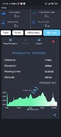
1. Elevation finder and activity tracker.
2. The app has a unique database of many trails around the world that was recorded by the users so you get the best hiking trails.
3. The app finds your altitude, peak points, barometric pressure, speed, and more!
4. The app alerts you against altitude limitations and is suitable for a variety of activities such as Walking, Trekking, Flights, Cycling, Skiing, biking, and more.
Have you ever searched for "walks near me?" or find elevation? now you can get it immediately with ALT-LAS.
Help build a community that shares routes and places around the world.
Measuring altitude modes:
1. GPS mode: the application measures the altitude using the GPS and performs a unique correction to provide an accurate altitude.
Note, that the altitude readings may be inaccurate when the GPS signal is weak.
2. Barometer sensor (a device with a barometer sensor): the application can work with the device’s barometer sensor that is auto-calibrated with the environment.
In this mode, the application can work inside buildings without GPS.
Features:
- Track activities
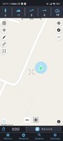
- Trail navigation
- Explore new trails
- Offline maps (Pro version)
- View Trails in 3D (Pro version)
- Track your elevation
- Altimeter to get your current altitude.
- Discover and share tracks
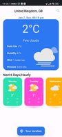
- Weather forecast
- Elevation map
- Compass with lock bearing
- Steps & Calories calculator
- Share live location (Subscription only)
- Real-time altitude graph
- Altitude limit alerts
- Save landmarks
- Barometric pressure
- Import/export GPX files
- Climbing information
- The Altimeter can work offline (flight mode)
- Get indoor/outdoors altitude
- Periodic altitude voice notification
- Different map types: Topographic, Open Street Map, hike & bike, and Satellite (Premium only).
- Sensor info (Supported devices only) such as Barometer, Temperature, Light, and Humidity.
- Dark mode
Planning and Navigation tools:
- Measure route and vertical distance
- Routing: get the fastest route between any location to another.
- Get coordinates on the map
- Estimate time of arrival
- Circular boundary
Note: If the app closes/crashes while opening 3D view, then open app again. It might happen on first time.
What's New:
1. Added an option to link points of interest to the activity.
2. Address bugs
3. User interface improvements
Download the ultimate activity tool today!
ALT-LAS Can be used as a Bike computer use it on your bike, bicycle, scooter, and more!
By using the app you can get:
1. Elevation finder and activity tracker.
2. The app has a unique database of many trails around the world that was recorded by the users so you get the best hiking trails.
3. The app finds your altitude, peak points, barometric pressure, speed, and more!
4. The app alerts you against altitude limitations and is suitable for a variety of activities such as Walking, Trekking, Flights, Cycling, Skiing, biking, and more.
Have you ever searched for "walks near me?" or find elevation? now you can get it immediately with ALT-LAS.
Help build a community that shares routes and places around the world.
Measuring altitude modes:
1. GPS mode: the application measures the altitude using the GPS and performs a unique correction to provide an accurate altitude.
Note, that the altitude readings may be inaccurate when the GPS signal is weak.
2. Barometer sensor (a device with a barometer sensor): the application can work with the device’s barometer sensor that is auto-calibrated with the environment.
In this mode, the application can work inside buildings without GPS.
Features:
- Track activities
- Trail navigation
- Explore new trails
- Offline maps (Pro version)
- View Trails in 3D (Pro version)
- Track your elevation
- Altimeter to get your current altitude.
- Discover and share tracks
- Weather forecast
- Elevation map
- Compass with lock bearing
- Steps & Calories calculator
- Share live location (Subscription only)
- Real-time altitude graph
- Altitude limit alerts
- Save landmarks
- Barometric pressure
- Import/export GPX files
- Climbing information
- The Altimeter can work offline (flight mode)
- Get indoor/outdoors altitude
- Periodic altitude voice notification
- Different map types: Topographic, Open Street Map, hike & bike, and Satellite (Premium only).
- Sensor info (Supported devices only) such as Barometer, Temperature, Light, and Humidity.
- Dark mode
Planning and Navigation tools:
- Measure route and vertical distance
- Routing: get the fastest route between any location to another.
- Get coordinates on the map
- Estimate time of arrival
- Circular boundary
Note: If the app closes/crashes while opening 3D view, then open app again. It might happen on first time.
What's New:
1. Added an option to link points of interest to the activity.
2. Address bugs
3. User interface improvements
*Special Features*
☸ Premium/Paid features Unlocked
☸ 3D/Sattelite View Enabled
☸ Ads Free (Except credit ads)
☸ Optimized and cleaned resources for fast load
☸ Original Signature changed
☸ Debug Info Removed
☸ CPUs: Universal
♤ credit ♤ ➥ Mod By Mr Intruder
Free Download:
! Hidden Content !
You must be registered and either click Like under this post or leave a comment before you can see the hidden links.
You may need to refresh the page after clicking Like. If you’re still having trouble revealing the hidden links, please
read this.
Did you know? VIP Members can see all links instantly, no unlocking required.
Interested? Get VIP here.
Interested? Get VIP here.