Playstore Link :
Spyglass Ver. 3.9.11 MOD APK l Premium, Paid Unlocked
Requirements: 9.0+
Overview: Spyglass is an essential offline GPS app for outdoors and off-road navigation.
Image
Packed with tools it serves as binoculars, heads-up display, hi-tech compass with offline maps, gyrocompass, GPS receiver, waypoint tracker, speedometer, altimeter, Sun, Moon and Polaris star finder, gyro horizon, rangefinder, sextant, inclinometer, angular calculator and camera. It saves a custom location, navigates precisely to it later, shows it on maps and using augmented reality displays detailed GPS info, measures distances, sizes, angles, and does a lot more.
INPORTANT NOTE ON ANDROID RELEASE
One of the best cross-country GPS navigation tools is now available on Android. Most features are implemented, however, some features available on other platforms are to be done. The multi-target tracking, star catalogue and coordinate converter will come later as a free update. Also, instead of having multiple apps, on Android it is a single free app with a paid unlock of premium features.
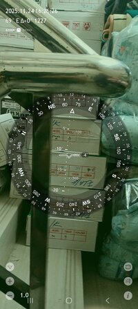
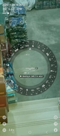
COMPASS & GYROCOMPASS
Accuracy improvement techniques, special compass modes and calibration methods available in Spyglass only make it a real instrument – the most advanced and accurate digital compass.
FINDER, TRACKER & AR NAVIGATION
Spyglass operates in 3D and uses augmented reality to show object positions, info and directions to them overlaid over camera or maps.
Save current position, add a point from maps, manually enter location coordinates.
Find the saved place later simply by following directional arrows.
Spyglass tracks your target and shows its info – distance, direction, azimuth, elevation and estimated time of arrival.
GPS, SPEEDOMETER & ALTIMETER
Find and track your location and get detailed GPS data – coordinates in dozens of formats, altitude, course, current, maximum and vertical speed, using imperial, metric, nautical and surveying units.
OFFLINE MAPS
See your and targets’ positions on maps using different map styles and alternative map providers – plan waypoints and measure distances. Offline maps optimized for retina displays are available for download.
TRACK POLARIS, SUN AND MOON & NAVIGATE BY STARS
Track positions of Polaris, Sun and Moon with arc second precision – use them as a reference to calibrate compass for maximum accuracy.
OPTICAL RANGEFINDER
Measure distances to objects in real time with a rangefinder reticle similar to sniper sights.
SEXTANT, ANGULAR CALCULATOR AND INCLINOMETER
Find out heights of objects and distances to them – measure visually and calculate dimensions and distances.
CAMERA
Take pictures overlaid with all available GPS, positional and directional data.
DEMO & HELP
Videos:
 j.mp
Manuals:
j.mp
Manuals:
 j.mp
j.mp
What's New:
- improved fullscreen support
- bug fixes and performance improvements
Requirements: 9.0+
Overview: Spyglass is an essential offline GPS app for outdoors and off-road navigation.
Image
Packed with tools it serves as binoculars, heads-up display, hi-tech compass with offline maps, gyrocompass, GPS receiver, waypoint tracker, speedometer, altimeter, Sun, Moon and Polaris star finder, gyro horizon, rangefinder, sextant, inclinometer, angular calculator and camera. It saves a custom location, navigates precisely to it later, shows it on maps and using augmented reality displays detailed GPS info, measures distances, sizes, angles, and does a lot more.
INPORTANT NOTE ON ANDROID RELEASE
One of the best cross-country GPS navigation tools is now available on Android. Most features are implemented, however, some features available on other platforms are to be done. The multi-target tracking, star catalogue and coordinate converter will come later as a free update. Also, instead of having multiple apps, on Android it is a single free app with a paid unlock of premium features.
COMPASS & GYROCOMPASS
Accuracy improvement techniques, special compass modes and calibration methods available in Spyglass only make it a real instrument – the most advanced and accurate digital compass.
FINDER, TRACKER & AR NAVIGATION
Spyglass operates in 3D and uses augmented reality to show object positions, info and directions to them overlaid over camera or maps.
Save current position, add a point from maps, manually enter location coordinates.
Find the saved place later simply by following directional arrows.
Spyglass tracks your target and shows its info – distance, direction, azimuth, elevation and estimated time of arrival.
GPS, SPEEDOMETER & ALTIMETER
Find and track your location and get detailed GPS data – coordinates in dozens of formats, altitude, course, current, maximum and vertical speed, using imperial, metric, nautical and surveying units.
OFFLINE MAPS
See your and targets’ positions on maps using different map styles and alternative map providers – plan waypoints and measure distances. Offline maps optimized for retina displays are available for download.
TRACK POLARIS, SUN AND MOON & NAVIGATE BY STARS
Track positions of Polaris, Sun and Moon with arc second precision – use them as a reference to calibrate compass for maximum accuracy.
OPTICAL RANGEFINDER
Measure distances to objects in real time with a rangefinder reticle similar to sniper sights.
SEXTANT, ANGULAR CALCULATOR AND INCLINOMETER
Find out heights of objects and distances to them – measure visually and calculate dimensions and distances.
CAMERA
Take pictures overlaid with all available GPS, positional and directional data.
DEMO & HELP
Videos:
Videos – Spyglass for iPhone, iPad, iOS and Android – Happymagenta
Video gallery of Spyglass, the best compass, GPS navigation and augmented reality app for iPhone, iPad, iOS and Android.
j.mp
Manuals – Spyglass for iPhone, iPad, iOS and Android – Happymagenta
Manuals and user guides of Spyglass, the best compass, GPS navigation and augmented reality app for iPhone, iPad, iOS and Android.
j.mp
What's New:
- improved fullscreen support
- bug fixes and performance improvements
*Special Features*
1. Premium / Paid Features Unlocked
Credit to : alex.strannik
Free Download:
! Hidden Content !
You must be registered and either click Like under this post or leave a comment before you can see the hidden links.
You may need to refresh the page after clicking Like. If you’re still having trouble revealing the hidden links, please
read this.
Did you know? VIP Members can see all links instantly, no unlocking required.
Interested? Get VIP here.
Interested? Get VIP here.